
Mt Rainier National Park Areas
Click on area on map or select area
NE
SE
Paradise
SW
NW
MPG V2.8, January 2013
Fall 2015
Background
Note.-- The northwest (Carbon River and Mowich Lake) area, the Southwest (Nisqually entrance) area and the Paradise (south-central) area have been updated. The other two areas, the northeast (White River and Sunrise) and southeast (Ohanopecosh), are scheduled for later in 2016.
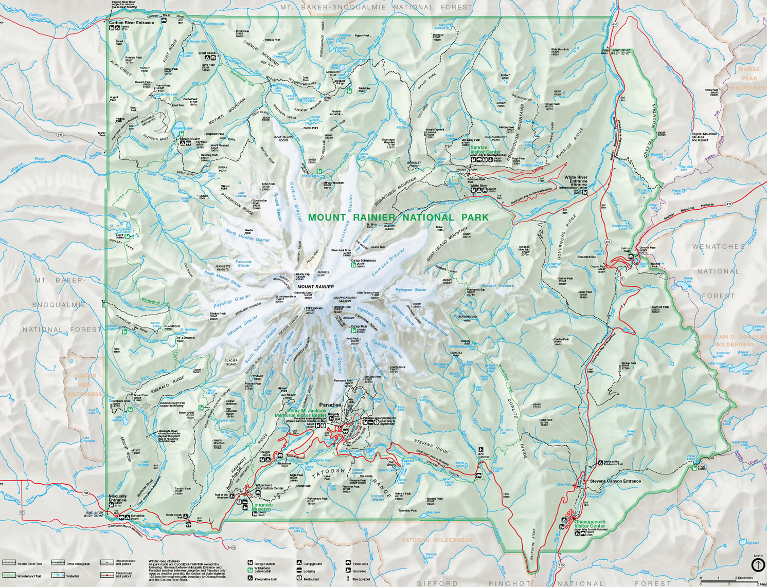
For the purposes of presenting a photography guide to Mt. Rainier NP, I have divided the NP into quadrants, based on the four access highways and entrances to the NP, and the Paradise area where the main visitors center is located. These areas will be presented in general below where you can get additional information with the link for each area, see the travel overview for a map and general travel information.
You can also click on the map or links above to navigate to individual area. You can get a larger view of the map NP map (560KB jpg).
Overview
September and October are the transition months from late summer into fall in the NP, with respect to the weather of both warm sunny days to the cooler fall days and cool to cold nights with periods of rain, and, in some years, the possiblity of snow in October, which has occurred 23 of the last 32 years.
It's also for the NPS to transition the vistor facilities, camgrounds and roads for the upcoming winter as well as preparation for possible extreme rain events with floods or snowstorms. This requires establishing and following a schedule to close all but one road and almost all the facilities through September and October, the rest closing in November.
Seasonal Weather
September and October are the transition months from summer to fall (September) and fall into early winter (October). September transitions from the warm, usually clear but occasional cloudy or overcast days and cool nights early in the month to cooler evening and overnight weather and cooler daytime weather with varying from clear and sunny to overcast with rain later in the month.
October is the continuation of that weather to consistently cool to cold weather with more rainstorms with rain and early snow in some years with periods of clear, sunny weather, often called indian summers or just good, nice weather to visit the NP. These months can be dynamic months for weather so it is best if you plan and prepare for the extreme weather.
You can get more information on the weather and snow for the NP with data for Longmire and Paradise in the NP.
Visitor Facilities
September is the month the NPS reduces days or hours of and closes some facilities, campgrounds, entrances and roads in preparation for the winter. The winter preparation continues through October the where by early November all of them are ready for winter with only the year-around facilities open through the winter with reduced days and hours.
You can get complete information on the visitor facilities from the NPS Website and via a map of location in the NP.
Roads & Highways
The same applies for the highways and roads in the NP and the state highways through the NP as for the facilities, etc., see above description. You can get more from the NPS Website on the status of roads with links to the NP's Twitter account, as well as the WSDOT Websites for highway 410 and 123 over Cayuse Pass and Chinook Pass.
Through this spring and summer the NPS has been repairing and repaving the highway between the Nisqually entrance and Paradise. This work was suspended for August and September to resume in October, so there will be altered traffic patterns in September but no delays. The delays will return in October until the end of the work for the season.
Trails & Trailheads
All of the trails will be snowfree into October and accessible through these months when and where the roads are open, see above description and links to information on road closures, especially the White River Road to the campground and Sunrise and Stevens Canyon Road between highway 123 and highway 706 to Paradise.
The trails will have far fewer hikers through both months especially the backcountry trails and the Wonderland trail. Most hikers will be found on the popular trails and within a few miles of the trailheads at the visitors' areas of Longmire and Paradise.
Visitors and hikers should check the weather for their visit and the NPS Website for hiking information and backcountry camping.
Planning & Preparation
For the most part, September and October shouldn't change your planning and preparation for visiting, hiking and photographing in Mt. Rainier NP except to be cognizant of the schedule to reduce hours or close facilities, campground and roads and the weather reports and forecasts.
However, into mid-late October, the chances for significant rainstorms and possible snow in the mid-upper elevations become likely as the weather transitions into late fall and early winter into November when and where some of the earliest seasonal snow and some of worst rain storms with flooding have occurred.
Area Overview
You can get an overview of the larger area of Mt. Rainier NP and a description of the general of the photography are in Mt. Rainier NP. Here is a brief description of ht area in the area guide.
The Paradise area is most visited area of the NP with the Jackson Visitors Center, Mountain Guide Center, and Paradise Inn. This area is also the longest drive from Seattle, Tacoma, or Portland, as it's just south of the mountain and near the center of the Park, accessible only by the highways inside the Park. Next to the Sunrise area the Paradise area has the closest view of Mt. Rainier with many short trails to viewing areas, great for photographs.
The Northeast area is most easily accessible area of the NP from Seattle, with the White River entrance and the road to Sunrise with the visitors center which is open July through September. It is accessed via highway 410 from Seattle on the way to Cayuse Pass or from Yakima over Chinook Pass. Highway 410 continues south into the Park as highway 123 to the southeast area and highway 12 as well as highway 706 to Paradise.
The Southeast area is the most accessible entrance from Portland via Interstate 5 to highway 12 or via the backroads east of Mount St. Helens Volcano Monument to Randle. It can also be accessed via highway 12 from Yakima over White Pass at Naches where it splits with highway 123 to highway 410 at Chinook Pass. You can also access the area via highway 7 at Morton to Elbe.
The Southwest area is the most accessed entrance for visitors from Tacoma via highway 7 south of Tacoma, or via highway 161 from Puyallup. The highway becomes 706 at Elbe to the Park entrance, to Paradise (Jackson visitors center), and onward to highway 123 in the southeast area. This area can also be accessed via highway 52 at Randle off highway 12 to highway 706 at Ashford.
The southeast and southwest areas are connected inside the NP by the Stevens Canyon Road, highway 706, between Paradise and the Ohanapecosh entrance off highway 123, and outside the NP by Skate Creek Road which connects to highway 706 west of the Nisqually entrance near Ashford to highway 12 at Packwood which connects to highway 123.
The Northwest area is accessed from either Seattle or Tacoma via highway 165. It is the least accessible as it's via rural highways from various locations to the split to the Carbon River entrance and the Mowich Lake entrance, each with their own access to the NP. In addition the Carbon River road is closed at the NP boundary (trail only), and the Mowich Lake road closes seasonally, usually October or the first significant snowfall to early July, earlier depending on snowmelt.
Access
The following is a summary of access to Mt. Rainier NP from their Web pages about the roads and facilities for the current conditions in the NP. It summarizes the basic information in a simplier form, and you can go to the NPS Web page for more and detailed information. The locations are listed by the area and entrance in the NP.
Nisqually Entrance, is open to Paradise. The Paradise Valley Road and the Stevens Canyon Road closes with the first snowfall. The NPS has been repairing and repaving the highway between the Nisqually entrance and Paradise. This work is suspended for August and September to resume in October, so there will be altered traffic patterns in September but no delays. The delays will return in October until the end of the work for the season.
The Longmire visitors center open daily until October and then Thursday through Mondays until spring. The Jackson visitors center is open daily until October and then only weekends and holidays until spring. The Paradise Inn closes in October. The Mountain Guide Center closes in October. The Cougar Rock campground closes in October.
Carbon River Entrance, is open at the NP Boundary to hikers, and to bikers, only on the Carbon River trail, to the Ipsut Campground. A backcountry permit is required for overnight stays.
Mowich Lake Entrance, The road closes in October or first heavy snowfall. The campground will be open with a permit through the fall and winter.
Ohanapecosh Entrance, Highway 123 from the NP entrance to Cayuse pass is open until closed for the season later in November. The Stevens Canyon Road will close in November or the first heavy snowfall. The Ohanopecosh visitors center is closed for the season and the campground closes in October.
White River Entrance, Highway 410 is open to Cayuse Pass and Chinook pass until closed for the season later in November. The White River entrance closes in October. The campground closes September 30. The road to Sunrise from White River campground closes in October. The Sunrise vistor facilities closes in September.
Resources
Below are sources for additional information about Mt. Rainier and the NP.
Please send e-mail if you have any questions.