
|
| |||||
|
|
|||||
|
Maps on Mount Rainier National Park
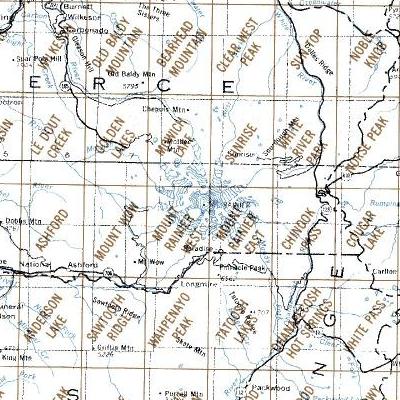
Above are a sections of the USGS map index for the latest version of the 7 1/2 minute (1:24,000) topographic maps covering Mt. Rainier NP. Below are the complete set of historical topographic maps for each section with the respective year of the update or or printing for each map and the years of USGS maps of the whole NP as part of a larger scale map. Information In 2014 the USGS released all of the historical topopgraphic maps in their collection, which includes the various scales maps covering Mt. Rainier NP and all the 7 1/2 minute topographic maps covering parts of the NP. The latter maps date from the first ones in 1971, some updated with photo revisions replacing the 1971 map. The 7 1/2 minute maps released before 2011 are the traditional topographic maps and are single layer PDF files easily viewed with any PDF reader application, such as Adobe Acrobat Reader or Pro, on any laptop or desktop computer or with any mobile device. The 2011 (available here) maps and the 2014 maps (latest available above or here) are multi-layer PDF files and require an application with the capability and tools to read these map files. Currently there are no applications for mobile devices for these files and their use is limited to applications on laptop or desktop computers. Historic Maps Below are the larger scale maps which covers Mt Rainier NP, from the first topographic map in 1915 to the latest update in 1978. These maps are produced in scales as noted with the footnotes. These maps are not the maps produced for specific National Parks which are not available in digital formats. Maps specifically for Mt. Rainier NP were produced in 1915, 1924, 1938 and 1971. The 1915 map here is a high resolution digital image of the original production (draft) map published in 1924. Notes about the maps.-- After reviewing the map it is clear that the maps, from the 1931 through the 1972 version, are reprints of the original 1924 map with the newer map designs and format larger scale maps with the updated NP boundary, other information (roads, trails, facilities, etc.) and placemanes, but does not reflect all the changes in the NP for the date stamped on the map (lower right corner). Use them with caution for accuracy for the date of the map. The 1978 maps is accurate for its date. |
|||||
| Maps of Mt. Rainier NP,
Years of Maps to Download | |||||
|---|---|---|---|---|---|
|
1915 East(a) 1924(c,e) 1954(c) |
1915 West(a) 1928(c) 1956(c) |
1924 Draft(f) 1931(c) 1961(c) |
1939(c) 1965(c) |
1945(c) 1972(c) |
1950(c) 1978(d) |
|
| |||||
| Historic USGS Topographic Maps,
Years of Maps to Download | |||||
|
Northern Maps- Golden Lakes - 1971, 2011 Mowich Lake - 1971, 2011 Sunrise - 1971, 2011 White River Park - 1971, 2011 Norse Peak - 1988, 2000, 2011 |
Central Maps Mount Wow -, 1971, 2000, 2011 Mt Rainier West - 1971, 1995, 2011 Mt Rainier East - 1971, 1995, 2011 Chinook Pass - 1971, 1987, 2011 Cougar Lake - 1988, 2000, 2011 |
Southern Maps Sawtooth Ridge - 1989, 1998, 2011 Wahpenayo Peak - 1989, 1998, 2011 Tatoosh Lakes - 1989, 1998, 2011 Ohanapecosh - 1989, 1998, 2011 White Pass - 1962*, 1988, 1998, 2011 |
|||
|
Footnotes: Mt Rainier NP maps are available for the latest or historical maps, along with Green Trails maps. Please use the contact link to send e-mail. | |||||
| [Top] [Guide] [Home] | |||||