
|
| |||||
|
|
|||||
|
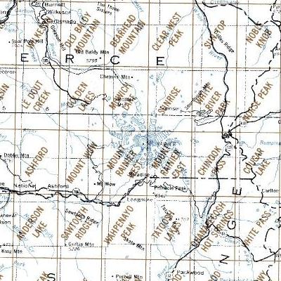
Maps on Mount Rainier National Park Above are a sections of the USGS map index for the latest versions of 1:24,000 topographic maps covering Mt. Rainier NP. Each of the 7 1/2 minute (1:24,000) topographic maps are also available from the USGS on their Map Locator server. This Web page is the download of those files and are the most current version compiled and produced by the USGS. Information The new maps are in the new multi-layer PDF file format with layers for the traditional topographic map, along with an orthophoto layer and information layers. These maps require an application which has the capability and tools to work with layers in PDF files, such as Adobe Acrobat Reader or Pro. Currently, however, there are no PDF applications to use these maps with mobile devices, such as smartphones or tablets. This limits their use to laptop or desktop computers. In addition, these PDF map files, above and listed below, are large, 25-35 MBytes, so the download can take time and you will need the accompanying disk space to accommodate them. You can also find other 7.5 minute topographic maps for Washington from Yellowmaps' map search Web page. |
|||||
| USGS PDF files topographic maps by name,
All Maps 2014 Version | |||||
|---|---|---|---|---|---|
|
Northern Maps Golden Lakes Mowich Lake Sunrise White River Park Norse Peak |
Central Maps Mt Wow Mt Rainier West Mt Rainier East Chinook Pass Cougar Lake |
Southern Maps Sawtooth Ridge Wahpenayo Peak Tatootsh Lakes Ohanapecosh White Pass |
|||
|
Mt Rainier NP maps are available for the latest or historical maps, along with Green Trails maps. Please use the contact link to send e-mail. | |||||
| [Top] [Guide] [Home] | |||||