
|
| |||||
|
|
|||||
|
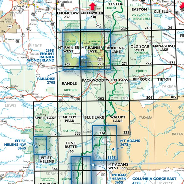
Maps on Mount Rainier National Park Note about Green Trails.-- Green Trails have redesigned their Website and removed the links to individual products, including maps, and now visitors must navigate through the Website to the state and the region, and then to the individual map to buy. This changes this Webpage where the links on the map (above) and the list (below) don't work for what I want. Visitors now have to go to the Web page for Washington maps. Above (map) and below (list) are the Web pages for the Green Trails maps of Mt. Rainier NP and adjacent lands on their map index. The topographic maps with trails and facilities use their 1:69,500 scale. Each of the nine maps are also available in paper print from their Map Locator server. Notes about the maps.-- Green Trails maps are excellent for their trail information, overlaying the topography, especially the Mt. Rainier East and West maps, and especially the special map for the whole NP focusing on the Wonderland Trail and the major summit routes. |
|||||
| Green Trails maps by name,
Print Year (Update Year) | |||||
|---|---|---|---|---|---|
|
Northern Maps Enumclaw - 1976 (2001) Greenwater - 1976 (2001) Lester - 1976 (2001) |
Central Maps Mt Rainier West - 1976 (2004) Mt Rainier East - 1976 (2001) Paradise Area - 1988 (2011) Bumping Lake - 1977 (2002) |
Southern Maps Randle - 1979 (2004) Packwood - 1976 (2004) White Pass - 1977 (2004) |
|||
|
Mt Rainier NP maps are available for the latest or historical maps, along with Green Trails maps. Please use the contact link to send e-mail. | |||||
| [Top] [Guide] [Home] | |||||