
Maps on Mount Rainier National Park
Find Latest and
Historical Maps.
MPG V2.8, January 2013
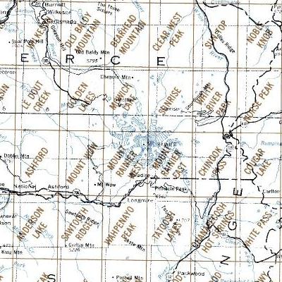
Above are a sections of the USGS map index for the 1:24,000 topographic maps covering Mt. Rainier National Park. You can use the map link to download maps or the links below to get more information and resources about these maps. The problem is that individual topographic quadrant maps are named for local features, as seen above, and don't necessarily follow an easy naming convention to locate individual maps.
Information
There are two recent updates for the USGS maps for Mt. Rainier NP. In 2014 the USGS released updates for the 7 1/2 minute (1:24,000) topopgraphic maps for Washington State, which included all 15 maps covering Mt. Rainier NP. The maps are the latest generation of PDF files with multiple layers with the traditional topographic layer, along with an orthophoto layer and different information layers.
Notes about maps.-- The latest version (2011 and 2014) maps require an application which has the capability and tools to work with layers in PDF files, such as Adobe Acrobat Reader or Pro. Currently, however, there are no PDF applications to use these maps with mobile devices, such as smartphones or tablets. This limits their use to laptop or desktop computers.
The second update is that the USGS released their entire collection of historical maps, which you can find a description and search tool on the USGS Website, or here for the historical 7 1/2 minute maps. You have to know the name of the quadrant, which also varys with the map scale, especially maps produced before the first 7 1/2 minute maps for an area.
Resources
You can get maps from the following sources for Washington and Mt. Rainier nmaps and for national map servers or information Websites.
- NPS Mt. Rainier Maps
- USGS Store - Follow Store Links
- USGS Map resellers in Washington
- USGS National Map
- USGS Map Viewer - Graphic Intensive
- NG Trails Illustrated Map
- Green Trails Maps
If you are in Seattle or plan to shop in Seattle, places to get maps and other supplies are Metskers Maps and REI's Flagship store along with any REI store around the Puget Sound. Some other outdoors and recreation stores also have maps. Maps are extremely helpful for adding to your knowledge and understanding of Mt. Rainier National Park to locate good photography locations, which are described in tourist guides, hiking and trails books, and on this Web site.
Mt Rainier NP maps are available for the latest or historical maps, along with Green Trails maps.
Please use the contact link to send e-mail.