
|
| |||||
|
|
|||||
|
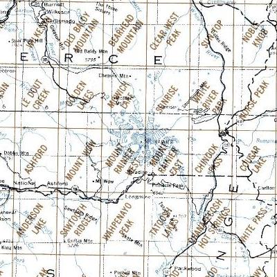
DRG Topographic Maps on Mt Rainier NP Updates.-- First (November 2010) the Web page was updated for new links when it was discovered the server for the maps had changed at the University of Washington Geomorphology Group. Second (April 2012) the Web page was updated with the year of the initial map production and any updated editions. Above are a sections of the USGS map index for the 1:24,000 topographic maps for Mt. Rainier National Park. Each of the twelve 7 1/2 minute (1:24,000) topographic maps are available by the USGS in DRG format courtesy of the Geomorphological Research Group at the University of Washington. The production of the maps are explained here and you should read the accompanying information about the files on the individual index Web page. Notes about files.-- The maps, also listed below, are compressed zip files produced in TIF format files which can be viewed, edited and printed with any image viewer or photo editor. The files are large, 6.5 to 7.0 Mbytes, so you will need the accompanying disk space to accommodate. In addition, since the original maps were obtained, they may not have been updated with revisions by the USGS. You can check the revision date on the map in the lower right-hand corner of the map. You may need to purchase updated digital files directly from the USGS, identifed on the map Web page. | |||||
| USGS DRG files topographic maps by name,
see Map Index
Print Year (Update Year) | |||||
|---|---|---|---|---|---|
|
Northern Maps Golden Lakes - 1971 Mowich Lake - 1971 Sunrise - 1971 White River Park - 1971 Norse Peak - 1971 (2000) |
Central Maps Mt Wow - 1971 Mt Rainier West - 1971 Mt Rainier East - 1971 Chinook Pass - 1971 (1987) Cougar Lake - 1971 (2000) |
Southern Maps Sawtooth Ridge - 1971 (1989) Wahpenayo Peak - 1971 (1989) Tatootsh Lakes - 1971 (1989) Ohanapecosh - 1971 (1989) White Pass - 1971 (1998) |
|||
|
Return to map Web page or PDF format. Please use the contact link to send e-mail. | |||||
| [Top] [Guide] [Home] | |||||