
Selected Unnamed Lakes in Mt Rainier NP
Find lakes via a Map and
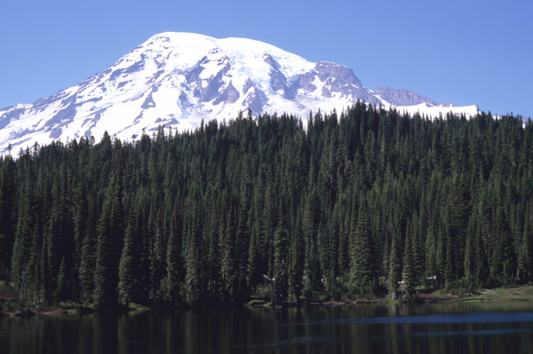
Named Lakes
MPG V2.8, January 2013
One of the biggest photography interests for the range of photographers are lakes, especially the scenic ones which are easily accessible by visitors. There are some excellent named lakes among the many lakes in Mount Rainier National Park, which are easily accessible from visitors areas and trailheads along with some documented unnamed lakes, which will be described here.
Background
There are currently 400 mapped lakes in Mt. Rainier NP, but less than 50 have official names listed on maps for the NP. Many of unnamed lakes are either small, remote or intermittent (seasonal or temporary) and haven't required a full identification with a name, or inclusion in publications or on maps.
The unnamed lakes in Mt. Rainier NP are in the backcountry or high elevation areas in the NP and are, for the most part, inaccessible via the trails in the NP, and requires backcountry and/or climbing experience and sometimes a permit for the area and any necessary camping.
In addition there is little if any information about these lakes as many have rarely been visited, and accounts of visits have rarely been documented or photographed, let alone published. Exception to these lakes are documented with a report published by the State of Washington in a series of reports from 1961 to 1973, see information section below.
Types of Lakes
The lakes in Mt. Rainier NP are divided into three catagories, two major ones and one obvious one. The major types are divided by their location, namely elevation, in relation to the treeline, where they are either surrounded by forests or above the treeline, and are open or in geologic features such as tarns, cirques, etc. The third type are the scenic or photogenic ones, most of which are alongside roads, see description.
For the photographer, the scenic or photogenic lakes are interesting for their beauty and view of Mt. Rainier as a backdrop. The two other types makes for a lot of interesting photo opportunities if you want to capture more than just Mt. Rainier itself. They afford you the opportunity to capture much of its uniqueness and nature. As they say, it's in the eye of the photographer, so I invite you to visit the named lakes, see description.
Information
There isn't much on-line or published information about the unnamed lakes in Mt. Rainier NP, and what does exist are often research studies related to water resources investigations or academic research. That said, here's a list I've found to date.
Water Quality of Selected Lakes in Mt Rainier NP, USGS WRI 85-4254, 1985.
Water Quality and Sediment Data for Selected Lakes in National Parks, USGS Data Series 751, 2008.
I'll add to this as I find more studies or reports.
Names of Lakes
In 1961 the State of Washington published a series of reports on the Lakes of Washington State which was updated in 1965 and 1973 (above link). This report indentified and located 45 named lakes and 41 unnamed lakes in Mt. Rainier NP.
Since these lakes don't have official names they can only be indentified by their location. The Web pages here with the unnamed lakes chose to use the original location used in the last report in the series published in 1973 which is the standard Township and Range designation with the State of Washington's system for land and groundwater locations, see map page and description (PDF), page 7.
This means the name is the township and range number with their respective compass directions, section number and the 40 acre subsection, eg. 10N07E36A. From this location and description in the report the lakes were located on maps and the latitude and longitude determined from the approximate center of the lake on a map.
Of the 41 unnamed lakes, one had been subsequently named and not included here but with the named lakes. Two lakes were not found to exist on current maps, one being a seasonal glacial-fed lake at the confluence of two streams, and the other being a beaver dam formed lake. The former is included for location purposes but the latter is not as it no longer exists.
No effort as this time is schedule to add anymore unnamed lankes or those with unofficial or informal names unless cited in official publications or on any official Website. There simply isn't the time to identify, locate and report the remaining 300 or so lakes in the NP.
Photography
The normal photography trips, described below, applies to these lakes as any lake in the NP, but it must be remembered these lakes aren't readily or easily accessible via trails which imposes additional work to hike to them with any appropriate permits for traveling off the establshed trails or camping outside the existing backcountry campsites.
There only a few tips anyone can give you to photograph lakes, and mostly it's being there at the right time with the right weather, the old adage, "timing is everything." That timing involves the season and month, the time of day, especially around sunrise and sunset, the moon rise and set, see information, and the weather, such as cloud cover, rain or snow and the wind.
The wind, or the lack of it, determines any possible reflections from the lake surface to the position of the camera. In addition, you should watch the foreground and background to frame the lake in the photograph. You should consider a range of wide angle lenses or a combination zoom to cover the range of views you can get of the lake from the different locations along with a macro lens to add the close foreground into focus.
After that there are two basic suggestions, which is the old adage about location. So while staying on the trails, walk around the lake to get range of views of it with the background. This also changes the direction of light for the different times you are there or want to come back.
Second, don't forget to hike above it to get overviews and photographs of it above lake level. It can give the view perspective. Remember, however, as with your hike around the lake, stay on the trails and only venture off where it's obvious you won't damage the plants.
Boating and Fishing
While clearly not photography, a less common activity on the lakes in Mt. Rainier is boating and fishing, and while boating seems unlikely activity do to the small size of the lakes, Mowich lake being the largest, fishing, especially fly-fishing (once a hobby of mine), can be an enjoyable way to pass the time when not engaged in photography.
For both boating and fishing you can get the information and rules from the NPS Website.
Resources
You can find sources for maps. Please use the contact link to send e-mail.