
The Grindstone Trail, 1915
Display the map for 1971
MPG V2.8, January 2013
)
Introduction
The northwest area of Mt. Rainier was initially explored in 1833 by William Tolmie in an attempt to climb Mt. Rainier. He only got as far as the peak northwest of Mowich Lake in the northwest quadrant of the NP which bears his name (Tolmie Peak) and where a lookout has resided since 1932.
Outside of miners after him who explored the northwest area around Mt. Rainier and worked some claims, there was little interest in the area until the Northern Pacific Railroad built for spur lines after they completed the track across the Cascade Mountains to Tacoma. One spur line ended near Wilkerson.
The railroad's initial interest was tourism and to that end they needed to get information about the area for any prospects and routes. They dispatched a young geologist, Bailey Willis, who initiated explored the area for tourism and developed the main trail from Wilkerson into the northwest area of Mt. Rainier.
That trail was the Grindstone Trail, one of the oldest trails to and in Mt. Rainier NP which was built from Wilkerson to the initial end at Crater Lake, now called Mowich Lake, later to Spray Park and eventually to the Carbon Glacier. Another trail was built from the original crossing of the Carbon River up the Carbon River valley to the junction with the Grindstone trail at the junction of Cataract Creek and the Carbon River.
History
As people were exploring to climb Mt. Rainier shortly after the first settlements in the southern Puget Sound, the majority of the trips to Mt. Rainier were through the southwest part of the NP, first to Longmire and then to the open meadow area on the south-central side of the mountain they called Paradise Park, now the area of the visitors center and Paradise River Valley, map of NP.
The one exploration to climb Mt. Rainier from the northwest part of the area was in 1833 which ended at Tolmie Peark when they returned. Outside of miners, there was little exploration was done between then and the 1870's. It wasn't until the Northern Pacific Railroad decided to explore a route on the north side of Mt. Rainier that a trail was needed into the northwest area.
The NP Railroad sent Bailey Willis to explore the area which necessitating building the 20-mile trail between 1881 and 1883 to Mowich Lake. The trail left Wilkerson southward crossing the Carbon River at a point upstream of Evans Creek at the town of Upper Fairfax.
The trail then followed Evans Creek for about two miles before crossing the creek and up to and along the divide of Evans Creek with Voight Creek basin to their headwaters, and then along the right bank above the Mowich River to the Meadow Creek to end at the outlet of Mowich Lake. Except for the first few miles the trail, it followed what is now, highway 165, and except for a 1 1/4 mile trail at the end, the Grindstone trail has been built over or lost to history.
)
Later Bailey Willis built Grindstone Camp, sometimes called Palace Camp, with 4 buildings about four miles west of the NP boundary in an open area on the hillside above the conflunce of Voight Creek with the Mowich River for visitors on their way to Mt. Rainier. The local Tacoma newspaper referred to the camp as "the lone lodge in the Wilderness" for its remoteness.
Bailey extended the trail from Spray Park to the Carbon Glacier and then down the Carbon River to the junction with the original Grindstone Trail where it crossed the Carbon River. Not much is known of the Carbon River part of the trail is known or remains as the NPS has changed trails in the NP over the years and the Carbon River road was built on the south side of the river where the Wilkerson trail was on the north side of the river.
Additional trails, along with the Grindstone trail, Carbon River trail and the "Willis Trail" built to connect the Grindstone trail at Grindstone camp with the southwestern part of Mt. Rainier through the Busy Wild Creek area, were developed in support of mining claims and for travel and the transportation of goods in the remote areas around Mt. Rainier.
These trails were included in a map of the area made by the Army Corps of Engineers in 1907. The 1907 map was produced in the initial work for the engineering for roads which were planned for the new NP. Only the improved road from Longmire to Paradise was built in early years of the NP.
)
That road was followed by the Carbon River road from the NP entrance to the Ipsut Creek campground by 1924 and the Mowich Lake Road from the NP entrance to Mowich Lake by 1935. These were followed by the State highway (410 and 123) on the east side and the White River road to the campground and to Sunrise.
Present Day
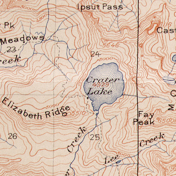
As noted the Grindstone trail from Wilkerson to the Mowich Lake NP entrance at the NP boundary is effectively lost to history and from the boundary to Mowich Lake only 1 1/4 miles of the original trail exists as a trail true to the original route to Mowich Lake. The trail from the NP boundary to the first trailhead at the head of the meadows is now the Mowich Lake road.
The only remaining part the trail you see today, the "Pack Trail" on 1971 NP map, starts at the trailhead at the curve at the head of the meadows, crossing the road three time down to Mowich Lake to the road near the most western edge of the lake where the road to the campground has replaced the trail.
From Mowich Lake the old trail to the Spray Park trail and to the Wonderland Trail across Spray Park to Cataract Creek and the Carbon River has been changed over the years as the NPS built new or rebuilt trails. From the junction of the Carbon River the trail followed the current trail down the Carbon River to Ipsut Creek campground and up the Carbon River to Carbon Glacier.
1896 USGS Expedition
The Grindstone and Carbon River trails were used by the US Geological Survey expedition team in 1896 lead by Israel Russell and others along with Bailey Willis and his 10-year daughter Hope. The team followed the Carbon River trail to the Carbon Glacier where trails ended and they established a camp on the northeastern side of Mt. Rainier.
The expedition returned to the junction of the Grindstone trail to Mowich Lake and Carbon River trail where they spilt into 2 groups to meet at the junction of the two trails at the Carbon River crossing south of Wilkerson. They split into groups, the Grindstone Trail to explore other features in Spray Park and the Carbon River trail with supplies due to threats of forest fires in the area around the NP.
Resources
There are very few resources about the Grindstone trail as it has disappeared outside of the remanent length near Mowich Lake. All I have found are general descriptions and history and a few maps beyond produced after Mt. Rainier NP was established in 1899.
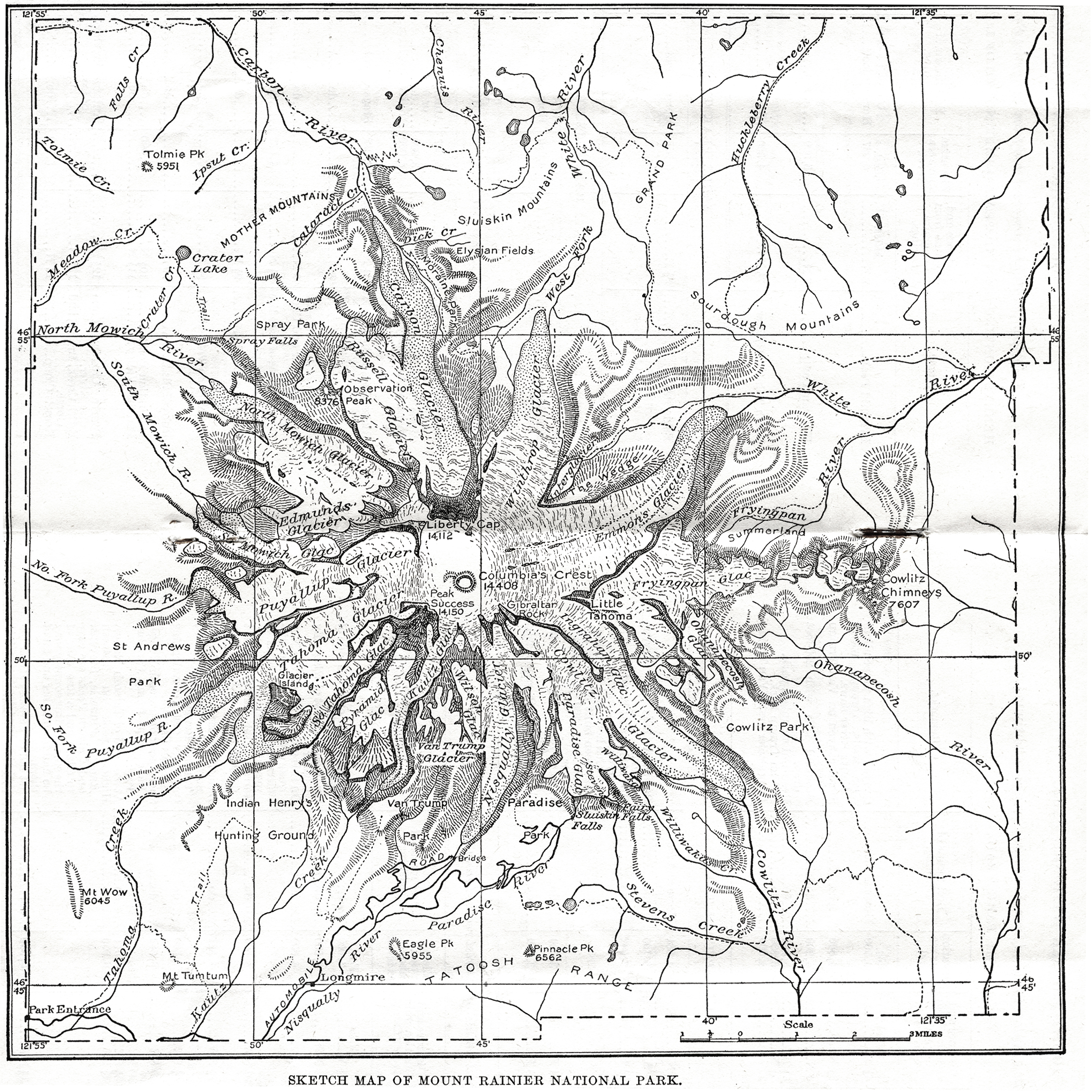
The map of the trail on the top of this Web pages is from an high resolution image of an original 1915 print of the USGS topographic map of Mt. Rainier NP from the Bailey Willis archives at the Huntington Library in the Los Angeles area. Bailey Willis wasn't involved in the surveys for the map but was involved with the information on the map from his work in the NP.
The portion of the 1907 map is from a high resolution scan of an original print of the map in the University of Washington Special Collection map library. They also have a 1914 panoramic view of Mt. Rainier NP used to produced the 1915 topographic map. The 1914 map is an artistic representation of the topography.
Please use the contact link to send e-mail.