
The Survey of Mount Rainier
F. E. Matthes
MPG V2.8, January 2013
Publication Note
This article was published in the The Mountaineer, volume 8, 1915, pages 61-66 with the permission of the Director of the U.S. Geological Survey. Mr. Matthes was the Chief Cartographer of the USGS at the time and oversaw the production of the 1915 topographic map of Mt. Rainier NP. It is reproduced here with the complete text with accompanying illustrations, hopefully better ones to be added in the future.
This article is important in the context of the 1915 topographic map to provide the perspective and background of the USGS at the time of the release of the map. It provides excellent information which can not be found in other sources. When resources are available, a PDF version, again hopefully with better illustrations, will be provided with a link here.
Note to reader.-- All transcriber inserted notes are shown in this color in the text of the article. These notes are not part of the original but simply for additonal clarity or information.
The Survey of Mount Rainier
Now that the new topographic map of the Mount Rainier National Park, recently published by the U.S. Geological Survey, has had its first testing at the hands of The Mountaineeers, who last summer encircled the peak, it may be apropos to describe in a few words how that map was made and, incidently, how the height of Mount Rainier itself was measured. The more desirable does it seem to do so, as to the layman modern topographic methods are still largely enshrouded in mystery, so that he has little whereby to judge of the merits of the map or of the reliability of an altitude determination. Several figures have been announced within the last two decades for the elevation of Mount Rainier, no two of them in accord. It may be well, therefore, to show why this new figure, for which finality has been claimed, is more trustworthy than the others.
Like all other topographic maps now being made in the United States, that of Mount Rainier was constructed wholly "on the ground." Time was - not long ago either - when "accurate" maps were based on transit-and-chain surveys, the notes of which were laboriously reduced and plotted - in an office, perhaps 2,000 or 3,000 miles away. The real drawing of such maps often was not begun until after the field work had been completed; and, as errors and ommissions cropped up occasionally in the nates an sketches (for even the most conscientious mind will err), it happened now and then that the draftsmen were obliged to eke out facts with ingenious fiction. It is possible that the layman's inborn distrust of the veracity of maps dates from those good old days. The modern topographer lays no claim to sheer perfection, but he at least enjoys the inestimable advantage of working with a method that leaves no very good excuse for mistakes or slips, and really no excuse whatever for straight ommissions. The philosophy of this system is that the map shall be drafted in the field, as fast as the measurements are available, and that the features of the landscape shall be sketched in then and there. When field work is finished, accordingly the map is finished too - in pencil - and needs only to be inked and engraved.
The instrument which makes this field mapping practicable is known as the plane table, by which cryptical appellation is meant a simple drawing board mounted on a tripod and so fitted that it can be leveled, turned at any angle and clamped rigidly in any position. On this table, securely fastened by thumb-screws, is a stiff sheet of double-mounted paper, upon which the manuscript map grows inch by inch, as slowly as an intricate piece of embroidery. The same sheet may be in use an entire field season, or perhaps several seasons (one of the Rainier sheets saw service three different years). It is worked on almost every day, yet, incredible though it may sound, that sheet will reach the office bright enough to be called white. Some people experience difficulty in keeping a drawing table reasonably clean for a single week indoors. Of course, the plane table sheet is carefully protected by stout manilla paper, only a tiny patch exposed for the work in hand, and is transported in a water-proof leather case.
On the plane table, resting directly on the map, is the alidade, the map maker's instrument par excellence, which take the place of the surveyor's traditional transit. It has a telescope, level and vertical arc, besides the various attachments devised to expedite its use. At its base is a flat ruler, about 18 inches long, which permits lines being drawn upon the map parallel to the line of sight. The laborious reading and subsequent plotting of deflection angle is done away with. The topographer simply sets the alidade with its ruler on the point occupied by him (marked by a fine needle hole in the paper), sights the object to be located, and draws a sharp line with a hard chisel-pointed pencil (7H to 9H, according to the humidity of the air and the paper). The method is both shorter, and more accurate in its results, than the old-fashioned process.
Chain and tape are also dispensed with. In the telescope are fitted, besides the customary cross hairs, two horizontal stadia hairs, which are so spaced that on a rod held at a distance of 100 feet they subtend one foot, at 200 feet, two feet, and so on. To measure the distance to a given point the topographer need but send his rodman there, and count the hairs, and multiply his reading by 1000. Whether the point to be located lie on the other side of the canyon or of a lake, makes no difference - so long as his rodman can reach it, a single peep through the instrument will give him the desired distance. At the same time he can determine the elevation of that point. The vertical arc shows him the angle which the telescope makes with the horizontal, and with this angle and the distance determined, he computes the difference in elevation between the point sought and his instrument. Special attachments reduce the arithmetical work involved to a few simple figures. Thus the topographer is able to work swiftly, locating point to right and left, as far as a thousand feet or more, plotting them forthwith and drawing the contours in accordance with the elevation.
Not all points needed, however, are accessible to a rodman. On the rugged flanks of a high peak, such as (Mount) Rainier, or a range such as the Sluiskin Mountains, there are many points the location of which is essential to support the numerous contour lines, yet which is manifestly impracticable to reach by stadia. Such points the topographer locates by intersection that is, by sighting them with alidade from at least two stations already plotted. This lines of sight drawn from the stations cross or intersect each other, and thus determine with accuracy the position of each point. Above timber line there is no lack of suitable targets - rock spires, cliff corners, spurs and reentrants, rock islands (called nunataks) in the midst of glaciers, as well as the edges and broken cascades of the ice masses themselves (the movement of which is too slow to produce changes in the course of a few days that would be perceptible on a scale of one mile to an inch). It is wonderful, with good weather conditions, at what distances such topographic details can be intersected with the aid of a telescopic alidade. Thus practically the entire southern side of Mount Rainier, from Little Tahoma west to Peak Success and down to 7,000-foot level, was mapped by intersections from Pinnacle Peak and other loctions on the Tatoosh Range. Considerably over 500 points lay within this area (which embraced about 12 square miles) the great majority of them, between 5 and 6 miles distant from the station occupied. Vertical angles were read to all of them, and thus 500 elevations were made available for the drawing of the contour lines. There were more than 70 of these lines, the total relief amounting to considerably over 7,000 feet. Needless to say, it required more than one day to complete the task, each station was occupied for several days in succession. Even then the results was attained far more expeditiously than would have been possible with old-fashioned transit-and-notebook method.
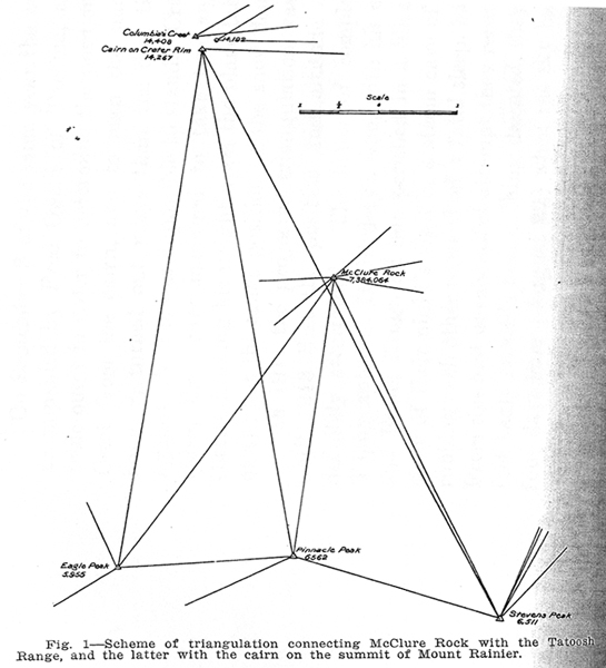
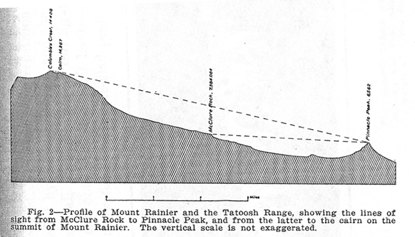
It was from the Tatoosh Range also that angles were taken for the determination of the altitude of Mount Rainier. It is the rule of the U.S. Geological Survey to establish important altitudes by accurate lines of spirit leveling, beginning at sea level or an already established base. Mount Whitney (14,501), the highest summit in the United States, was measured by that method, and so was Pike's Peak (14,100). But in the case of Mount Rainier, leveling was found wholly out of the question, not only because of the precipitiousness of snow chute up Gilbrator Rock, but because any attempt to carry accurate spirit levels over extensive snow slope, such as inevitably be traversed in the ascent of Mount Rainier, if fraught with difficulties innumerable. It was deemed more expedient, therefore, to measure the mountain's height by means of carefully checked vertical angles from neighboring peaks. The plan carried out, was first to determine the altitude of Pinnacle Peak, however, would have been almost as difficult as up Gibraltor Rock. It was decided, therefore, to run levels to McClure Rock, which is readliy reached by trail, and from that point to take vertical anglesto Pinnacle Peak, as well as Eagle Peak and Stevens Peak, by the way of check. From all three of these peaks, again angle were to be read to the summit of (Mount) Rainier. In order to insure the accuracy of the result, all points involved in this scheme, including McClure Rock, were to be bound together by triangulation, so that the distances between them could be computed to the nearest foot. The system of triangles is shown in Figure 1, shown above. A curious feature of the scheme is that the initial point, McClure Rock, is considerably higher than any of the peaks in the Tatoosh Range, so that the first step was really a step downward (Figure 2, shown below).
Unfortunately, the highest point on Mount Rainer - Columbia's Crest - is not visible from the Tatoosh Range, owing to the width of the summit crater. It was necessary, therefore, to select an auxiliary point on the crater rim that would be seen from the Tatoosh Range and from Columbia's Crest. This the writer did on his first ascent, August 18, 1910, in the company of Charles D. Walcott, Jr., and the guide Joe Stampfler. Sudden snow squalls compelled the party to beat a hasty retreat, but they managed, nevertheless, to erect a rock cairn 8 feet high to serve as a target for the triangular.
On September 3 of the same year the writer made a second ascent accompanied by Fred Owens of Tacoma, carrying a light plane table outfit in order to determine the position and height of Columbia's Crest from the cairn, and to map the summit itself. The weather, however, turned out worse than the first time, a fierce gale arising, against which is was impossible to stand. Crawling to the shelter of the cairn, the writer managed to take two angles to Columbia's Crest, Ownens, throwing his weight upon the plane table to keep it from blowing away; but the exact position of the snow dome remained undetermined.
In 1911 the projected triangulation was executed, but it was not until 1913 that the position and altitude of Columbia's Crest were definitely ascertained. The honor of completing the task belongs to Topogrpher C.H. Birdseye, who, with his companions C.B. Harmon and Frank Krogh all but perished in a blizzard on the summit. The story of their night's vigil in a steam cave of the crater, pounding and rubbing each other to ward off a fatal sleep, has been described elsewehere. From the first unsuccessful attempt they returned with ears, fingers and feet badly frosted; but, nothing daunted, they essayed the ascent again, four days later (August 20) when the sky cleared. That time the weather conditions were ideal, and in the space of five hours they succeeded in taking the necessary angles to the Tatoosh Range, in locating Columbia's Crest, and in mapping he entire summit platform.
Thus was completed the survey of Mount Rainier, which has resulted in placing the peak near the top of the list of high summits in the United States. The figure announced by the U.S. Geological Survey is 14,408 feet. The manifold repetition of each angle measured, the checks afforded by back readings, and the compactness of the triangulation scheme all combined to give this figure a degree of accuracy second only to one attainable by spirit levels - a mode of measurement impracticable on the flanks of an ice-clad peak.
Personal Notes
There's not much to add to the extensive work by the USGS during the summers of 1910-13 to map Mount Rainier NP and produce the first topographic map in 1915. It is a testament to the hard work, tenacity, dedication and perserverence of USGS personnel, long a trademark of the agency in providing the public with the best earth-science product in the world.
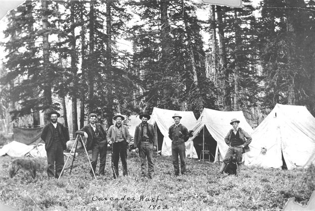
Please use the contact link to send e-mail. Photo from USGS archives.